Bukhansan Mountain Bike Guide: Seoul's Granite Edge | IMPT Travel
Granite spires loom over a city of ten million, and a subway ride drops riders at the trailhead. Bukhansan is less a bike park than a rare urban-edge singletrack experiment, ridden honestly within the rules.
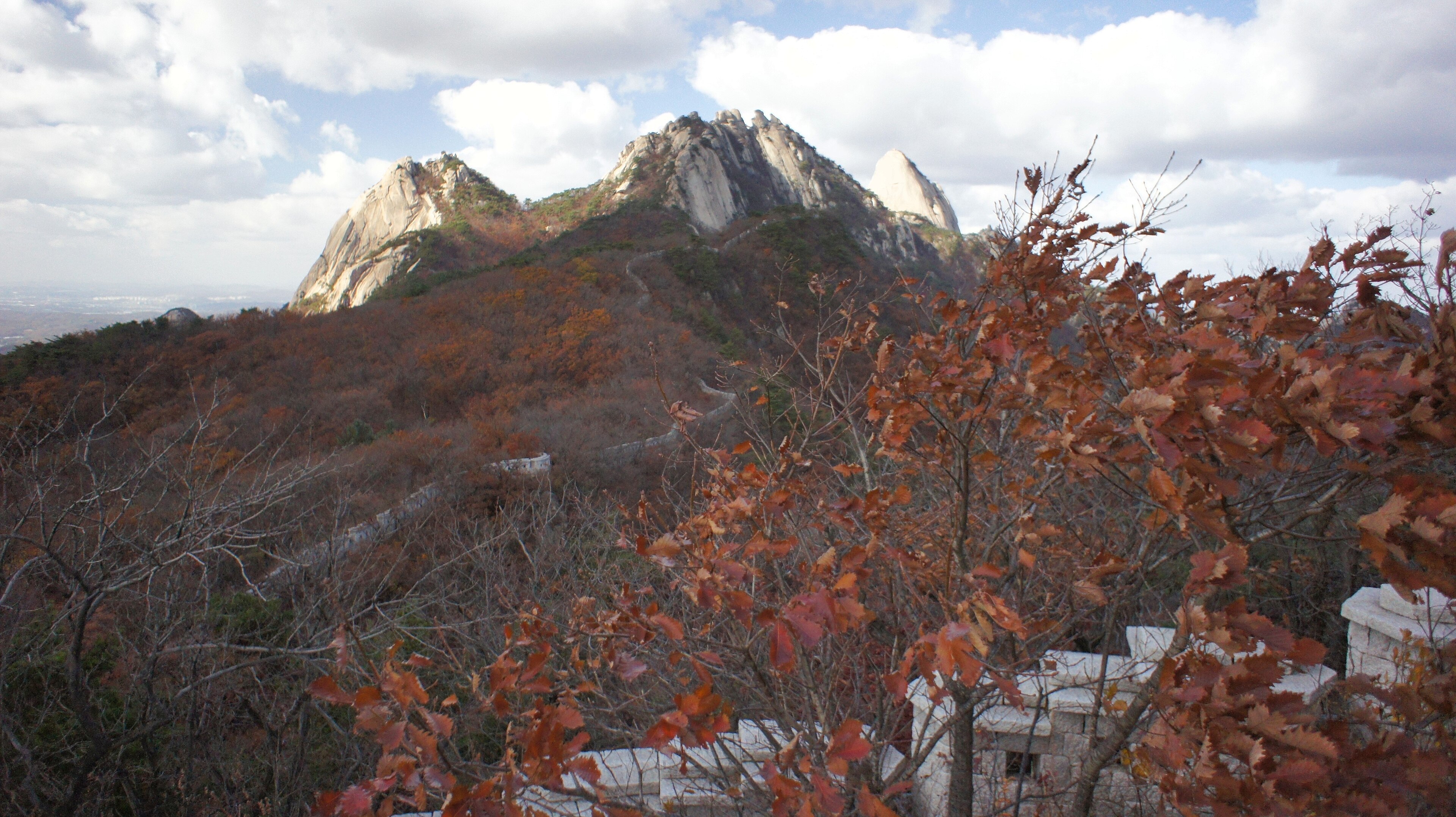
Five million pairs of boots a year cross the gates of Bukhansan National Park, making the granite massif on Seoul's northern fringe the most visited national park per unit area on the planet, according to the Guinness records the Korea National Park Service is fond of citing. A rider who exits Gupabal Station on Line 3 and looks north sees the same skyline the hikers see: the white granite domes of Baegundae (836.5 m), Insubong (810.5 m) and Mangnyeongdae (799.5 m) rising directly out of a city of ten million. The bike question is more complicated than the view suggests, and any honest guide has to start there.
The reality: a hiking park with riding around its edges
Bukhansan is not a built mountain bike destination. The interior summit trails — the granite scrambles to Baegundae and the cable-assisted lines up Insubong — are walking-only, and rangers enforce it. What riders actually use is the Dulle-gil, the 71-kilometre perimeter trail that loops the base of the massif in 21 sections, plus connecting fire roads, forest service tracks and the singletrack networks on the neighbouring Dobongsan and Suraksan ridges. Treated as a forest-floor cross-country zone rather than an alpine bike park, it delivers a riding experience that genuinely does not exist anywhere else on Earth: a metro card, a 40-minute train, and granite-flecked singletrack with a capital skyline behind every switchback.
Signature lines
The Dulle-gil perimeter (sections 8-15)
The most ridable arc of the Dulle-gil runs roughly from Jeongneung around to Uidong, with AllTrails community data putting one continuous segment at about 29 km. Expect packed dirt, root steps, stone staircases that demand a dismount, and short technical climbs through pine and oak. Grade-equivalent: blue to red, with the staircases pushing red on the descents.
Dobongsan service roads and ridge spurs
Accessed from Dobongsan Station (Lines 1 and 7), the eastern flank offers wider gravel climbs to viewpoints below the rock spires of Jaunbong and Manjangbong, with returning singletrack through the lower forest. The granite formations Korean climbers know as Uiam Rock dominate the skyline.
Mt. Udam loops, just south
For purpose-built tech, riders driving 40 minutes south to Mt. Udam find the Komoot-mapped Mt. Udam – Baegun Lake Loop (32 km, ~1,120 m vertical, graded hard) and the longer Mt. Udam – Seoyeonamugonrakji Loop (47 km, ~1,310 m vertical). These are the closest equivalents to all-mountain riding in the capital region.
No lifts, all legs
There are no chairlifts, gondolas or shuttle services at Bukhansan. Vertical is earned. The good news is that the highest park entrances sit between 100 and 200 m, the peaks top out at 836 m, and most ride days stack 600-900 m of climbing across multiple loops. Riders used to Alpine lift-served descents should recalibrate: this is cross-country endurance terrain with technical Korean granite stitched through it.
Getting there
Incheon International Airport (ICN) is the gateway. The AREX Express train reaches Seoul Station in 43 minutes; from there, Seoul's metro delivers riders to the trailhead with bike-friendly carriages on weekends and outside peak hours.
- Bukhansanseong entrance: Gupabal Station (Line 3, Exit 1), then bus 34, 704 or 8772 — about 17 minutes.
- Jeongneung entrance: Gireum Station (Line 4, Exit 3), then bus 110B or 143 — about 13 minutes.
- Dobongsan entrance: Dobongsan Station (Lines 1 and 7, Exit 1) — a 20-minute walk to the gate.
Total airport-to-trailhead time runs around 90 minutes by public transport, which is part of what makes Bukhansan unusual. The currency is the Korean won (KRW); cash is rarely needed and T-money transit cards are sold at every convenience store. English signage at park entrances is good; deeper into the trail network it thins to Korean only, so a downloaded offline map matters.
Season window
Two windows work, and the rest of the year fights back.
- Autumn (mid-September to mid-November) is the prime season. Daily highs settle between 10 and 20 °C, humidity collapses, the monsoon is over, and the maples colour the forest floor through late October. Peak weekends are crowded — start at dawn.
- Spring (April to early June) is the second window: cherry and azalea bloom, temperatures climb through the teens, and trails dry out.
- Summer (late June to August) brings the Korean monsoon — heavy, sustained rain into July, then high humidity and the typhoon tail through August. Trails turn greasy and erosion is a real concern.
- Winter (December to February) drops to -5 to -10 °C with snow and ice on north-facing aspects. Park operating hours shorten to 04:00-16:00, and bare-tyre riding becomes a serious proposition.
Where to stay, and the lighter footprint
Most visiting riders base in Eunpyeong or Insadong for metro access to all three trail gates; Eunpyeong Hanok Village offers traditional guesthouses within minutes of the Bukhansanseong entrance. The sustainability case for Bukhansan is unusual and worth naming: Seoul's metro and bus network reaches every trailhead, which means a rider can spend a week here without renting a car. Combined with the park service's strict trail-protection rules — bikes off the granite summit trails, full stop — Bukhansan rewards riders who treat it as a quiet, low-impact session in a working national park rather than a playground.
Ride the perimeter, walk the summits, and Seoul will reveal a granite ridge that almost no one outside Korea knows can be ridden at all.
Find a hotel in Bukhansan
Same prices as Booking.com. 1 tonne CO₂ retired per stay. €5 credit on signup.
Search now →